


|
基本信息Personal Information
博士生导师
曾获荣誉:
校级最受学生欢迎老师 校级优秀共产党员 本科教学质量评估优秀 华为ICT大赛全国一等奖指导老师 华为ICT大赛全球一等奖指导老师
性别 : 男
出生年月 : 1986-03-01
学历 : 博士研究生毕业
学位 : 博士学位
在职信息 : 在岗
所在单位 : 数据科学与大数据技术系
入职时间 : 2017-07-01
学科 : 地理信息科学. 空间信息与数字技术. 计算机科学与技术
个人简介Personal Profile
阎继宁,男,副教授,博士生导师,IEEE Senior Member,高校GIS新锐(2024),自然资源部高层次科技创新人才工程青年科技人才(2025),国际数字地球学会中国国家委员会委员、空间地球大数据专委会副主任委员、青年科学家工作委员会副主任委员,中国图象图形学学会遥感图像专业委员会委员,中国遥感应用协会定量遥感专业委员会青年委员,中国太平洋学会海洋大数据与高性能计算分会理事。主要从事遥感数据高性能处理与时序智能分析、遥感云计算研究。主持国家自然科学基金青年项目及面上项目、国家重点研发计划子课题、省重点研发计划课题、中国计算机学会科研基金等项目十余项。在RSE、ISPRS P&RS、JAG、IEEE GRSM、IEEE TGRS、Information Fusion等期刊一作/通讯发表SCI检索论文38篇,ESI高被引论文3篇,授权发明专利19项(排名第一11项),出版中英文专著3部,第一作者主编教材1部,获得日内瓦国际发明展金奖、第四届“ScienceDB”科学数据奖、测绘科技进步二等奖、中国产学研合作创新成果二等奖、IEEE JSTARS 最佳论文奖等,美国地质调查局遥感手册(第二版)“遥感云计算”章节主要编写人。担任“地质一号”遥感卫星数据处理主任设计师,入选2025年中国矿业十大新闻、2025湖北十大科技进展,《遥感学报》封面报道;期刊Remote Sensing编委,Resources, Environment and Sustainability (RES)、《地球科学》《Journal of Earth Science》《地质科技通报》青年编委,期刊ISPRS P&RS(一区Top,IF 12.2)最佳审稿人奖(Top Reviewer Award 2024-2025)。
欢迎人工智能、大数据、软件工程相关方向学生报考硕、博士研究生!
代表性论文:
[1] Jining Yan, Jingwei Liu, Dong Liang, Yi Wang, Jun Li, Lizhe Wang. Semantic segmentation of land cover in urban areas by fusing multi-source satellite image time series. IEEE Transactions on Geoscience and Remote Sensing, 2023, doi: 10.1109/TGRS.2023.3329709.
[2] Jining Yan, Lizhe Wang, Haixu He, Dong Liang, Weijing Song, Wei Han. Large area land cover changes monitoring with time-series remote sensing images using transferable deep models. IEEE Transactions on Geoscience and Remote Sensing, 2022. DOI: 10.1109/TGRS.2022.3160617.
[3] H. He, J. Yan*, L. Wang, D. Liang, J. Peng and C. Li, "Bayesian Temporal Tensor Factorization-Based Interpolation for Time Series Remote Sensing Data with Large-Area Missing Observations," in IEEE Transactions on Geoscience and Remote Sensing, doi: 10.1109/TGRS.2022.3140436.
[4] Jining Yan, Lizhe Wang, et al. "A time-series classification approach based on change detection for rapid land cover mapping." ISPRS Journal of Photogrammetry and Remote Sensing 158 (2019): 249-262.
[5] Jining Yan, Lizhe Wang, Kim-Kwang Raymond Choo and Wei Jie. A cloud-based remote sensing data production system. Future Generation Computer Systems. 2017. http://dx.doi.org/10.1016/j.future.2017.02.044.
[6] Nan Wu, Jining Yan*, Dong Liang, Zhongchang Sun, Rajiv Ranjan, Jun Li. High-resolution mapping of GDP using multi-scale feature fusion by integrating remote sensing and POI data, International Journal of Applied Earth Observation and Geoinformation, 2024, 129, 103812.
[7] Haixu He, Jining Yan*, Dong Liang, Zhongchang Sun, Jun Li, and Lizhe Wang. Time-series land cover change detection using deep learning-based temporal semantic segmentation. Remote Sensing of Environment 305 (2024): 114101.(ESI高被引)
[8] Yi Li, Jining Yan*, Liheng Zhong, De Bao, Leigang Sun, Guangyu Li. Full-Coverage Mapping of Daily High-Resolution XCO2 across China from 2015 to 2020 by Deep Learning-Based Spatio-Temporal Fusion, IEEE Transactions on Geoscience and Remote Sensing, 2025. 10.1109/TGRS.2025.3540289.
[9] Jining Yan, Sheng Wang, Jiaxin Feng, Haixu He, Ziyong Sun, Lizhe Wang. New 30-m resolution dataset reveals declining soil erosion with regional increases across Chinese mainland (1990-2022). Remote Sensing of Environment. Volume 323, 1 June 2025, 114681.
[10] Zaiyan Zhang, Jining Yan*, Yuanqi Liang, Jiaxin Feng, Haixu He, Li Cao. Multi-scale Restoration of Missing Data in Optical Time-series Images with Masked Spatial-Temporal Attention Network, IEEE Transactions on Geoscience and Remote Sensing, 2025. DOI: 10.1109/TGRS.2025.3574799.
[11] Enzhe Sun, Yongchuan Cui, Peng Liu*, Jining Yan*. A Decade of Deep Learning for Remote Sensing Spatiotemporal Fusion: Advances, Challenges, and Opportunities. Information Fusion. Volume 126, Part B, February 2026, 103675. https://doi.org/10.1016/j.inffus.2025.103675.
[12] Lingjun Sun, Ming Jin, Jining Yan*, Haixu He and Li Cao, "Semantic-TemporalNet: A Novel Urban Block Change Detection Method Based on Semantic Coherence Analysis," in IEEE Transactions on Geoscience and Remote Sensing, doi: 10.1109/TGRS.2025.3611378.
[13] Haixu He, Jining Yan*, Lirong Liu, Xu Long, Runyu Fan, Zhongchang Sun. Monthly monitoring of urban development and renewal at the block-level in China using Sentinel-2 time series, Remote Sensing of Environment, Volume 332, 2026, 115070, doi:https://doi.org/10.1016/j.rse.2025.115070.(得到部领导关注)
[14] Lizhe Wang, Yifu Chen, Yuan Le, Jining Yan, Weijing Song, et al. Geology-1 : The First Hyperspectral Remote Sensing Microsatellite in China for Geological Resource and Environmental Survey and Monitoring. IEEE Geoscience and Remote Sensing Magazine 13(4):455-492. DOI:10.1109/MGRS.2025.3591805.
[15] Qinglin Yang, Yao Guan, Haixu He, Suzhen Yang, Haonan Sun, Jining Yan*. Monitoring of mangrove dynamic change with Landsat time series from 1987 to 2022 in the Beibu Gulf, China. International Journal of Applied Earth Observation and Geoinformation. Volume 146, February 2026, 105128. https://doi.org/10.1016/j.jag.2026.105128.
[16] He, Haixu, Jining Yan*, Zichen Jing, and Lizhe Wang. "On-Orbit SWIR Imagery MTF Compensation for the Geology-1 Satellite Using Cross-Spectral Structural Priors." IEEE Transactions on Geoscience and Remote Sensing (2026).
授权专利(部分):
[1] 阎继宁,章俊宝,王力哲,贺海旭,王玥玮。一种土壤理化性质降尺度方法、装置、计算机设备和介质。专利号:ZL202511605492.1。
[2]王力哲,任庆达,阎继宁,荆子晨,贺海旭,黄晓辉。地质一号卫星遥感图像波段间相对配准方法及装置。专利号:202512045361.9。
[3] 阎继宁,王力哲,孙灵军,金铭,贺海旭,王玥玮。一种城市街区变化检测方法、系统、设备及存储介质。专利号:ZL202510905181.0。
[4] 王力哲,阎继宁,陈伟涛,贺海旭,包德,袁野,宋维静,黄晓辉,冯如意,谌一夫,赵济。基于地质一号卫星遥感数据的共性产品生产方法和装置。专利号:ZL20251 0549459.5。
[5] 阎继宁,贺海旭,王力哲, 龙旭,宋维静,韩伟。土地覆盖变化监测方法、模型训练方法及相关装置。专利号:ZL202411930928.X。
[6] 阎继宁,周蓬尧,王力哲,章俊宝,宋维静,樊润宇。用于开放空间的目标提取方法、装置、设备及存储介质。专利号:ZL202411875582.8。
[7] 阎继宁,袁野,王力哲,包德,韩伟,王玥玮。基于多模态数据融合的地球化学数据预测方法及装置。专利号:ZL202411844299.9.
[8] 阎继宁,张再筵,王力哲,李军,韩伟,王玥玮。遥感图像序列的修复方法、装置、电子设备及存储介质。专利号:ZL202410556414.6。
[9] 阎继宁,王力哲,王志鹏,刘洪,邓泽,陈云亮。一种时空索引构建方法、装置、计算机设备及存储介质。专利号:ZL202111042088.X。
[10] 阎继宁,王力哲,刘洪,李军,黄晓辉,陈云亮. 数据存储方法、数据查询方法、装置、设备及存储介质. 专利号:ZL202311298376.0。
[11] 阎继宁,贺海旭,王力哲,李军,宋维静,韩伟. 土地覆盖变化监测方法、装置、电子设备及存储介质. 专利号:ZL202311126526.X。
[12] 阎继宁;李玉勤;王力哲;贺湘友;黄晓辉;陈云亮. 地理空间对象索引方法及装置、存储介质、计算机设备. 专利号:ZL202510220234.5
[13] 阎继宁,孙浩楠,贺海旭,杨素珍,贾仁明,张政。红树林密集时序检测方法及装置。申请号:202511811668.9。专利号:ZL202511811668.9。
[14] 王力哲,阎继宁,陈腊娇,赵灵军. 一种基于动态遥感数据驱动的溢油仿真参数优化方法. 公开日 2018.8.24, 专利号:ZL201410852667.4。
[15] 王力哲,樊润宇,阎继宁,陈方,刘鹏. 一种基于深度学习的地质灾害文献知识图谱构建方法. 专利号:ZL201911280552.1。
[16] 王力哲,成路肖,冯如意,阎继宁,宋维静,王圣. 基于多模型融合的人口分布估计方法、装置及存储介质 专利号:ZL202111095651.X。
[17] 王力哲,冯如意,陈佳,韩伟,陈小岛,阎继宁,宋维静. 可扩展的、带有信息增益策略的图像生成时空融合算法. 专利号:ZL201911280551.7。
代表性项目:
[1] 2025/03/01-2028/02/29,广西省重点研发计划,北部湾红树林生态系统密集时序遥感监测与修复潜力评估,联合申报单位课题负责人。
[2] 2025/01-2028/12,国家自然科学基金面上项目,面向中国城市土地动态制图的密集时序遥感语义变化检测方法研究,主持。
[3] 2022/11-2025/11,国家重点研发计划子课题,城市人居环境非空间可持续发展数据的空间化与数据的标准化技术,主持
[4] 2023/01-2024/06,CCF-蚂蚁绿色计算专项科研基金,基于卫星遥感的大气动态污染源排放的研究,主持。
[5] 2019/01-2021/12,国家自然科学基金青年科学基金项目,云计算环境下大规模多源遥感数据高效组织方法研究,主持。
代表性专著 & 教材:
[1] Lizhe Wang, Jining Yan, Yan Ma. Cloud Computing in Remote Sensing. 2019.7.10, CRC Press. ISBN: 978-1-138-59456-2.
[2] 阎继宁,陈云亮,王媛妮,宋维静。Python语言应用案例实践教程,科学出版社,2020,ISBN:978-7-03-065284-3.
[3] Lizhe Wang, Jining Yan, Yan Ma, Xiaohui Huang, Jiabao Li, Sheng Wang, Haixu He, Ao Long, Xiaohan Zhang. Cloud Computing in Remote Sensing: A Comprehensive Assessment of State of the Arts. Remote Sensing Handbook, Volume I, 2nd Edition, CRC Press, 2024. eBook ISBN: 9781003541141.
[4] Lizhe Wang, Jining Yan, Yan Ma, Xiaohui Huang, Jiabao Li, Sheng Wang, Haixu He, Ao Long, Xiaohan Zhang. Cloud Computing in Remote Sensing: A Comprehensive Assessment of State of the Arts. Remote Sensing Handbook(遥感手册), Volume I, 2nd Edition, CRC Press, 2024. 399-438. eBook ISBN: 9781003541141.
发布的基准数据集及开源代码:
[1] 土地覆盖时序变化遥感监测基准数据集CUG-FFireMCD1,依据全球火灾扰动事件制作的MODIS时序数据集,可以为遥感时间序列变化检测的模型优化和精度验证提供基准。访问链接https://github.com/CUG-BEODL/CUG-FFireMCD
[2] 时序遥感数据语义分割基准数据集,由采自新疆伊犁地区的Sentinel-2高质量光学无云时序遥感影像制作,可以为时序语义分割模型优化和精度验证提供基准。访问链接https://github.com/CUG-BEODL/MTAF-TST.git
[3] 时序遥感语义变化检测基准数据集及开源代码。访问链接https://github.com/CUG-BEODL/TSSCD
[4] 1990-2022年中国30m年水土流失空间分布数据集. 访问链接 https://doi.org/10.57760/sciencedb.12876(下载160余万次,获第四届“ScienceDB科学数据奖”)
[5] 2015-202年中国逐日0.1度XCO2数据集,访问链接:https://www.scidb.cn/en/detail?dataSetId=77d94c9a080c4011b639acd2452b9f62
会议及获奖:
[1] 2025-6,第五届全国空间信息产业与国际标准化会议,优秀青年报告奖。
[2] 2025-12,第二十三届中国遥感大会“专题论坛”,优秀报告奖。
[3] 2023-9,第三届可持续发展大数据国际论坛(FBAS2023), 北京,分会场共同主席
[4] 2023-8,全球智慧城市峰会暨第三届国际城市信息学大会(GSCS & ICUI 2023), 香港,分会场共同主席
[5] 2023-7, 第13届国际数字地球会议(ISDE2023),雅典,分会场共同主席
[6] 2022-11,第五届地学大数据国际研讨会(BED2022),武汉,分会场召集人
[7] 2020-1, 第四届管理工程、软件工程与服务科学国际会议(ICMSS 2020),武汉,本地主席
代表性工程研发成果:“地质一号”高性能数据处理与服务系统(http://geosat.com.cn/geo-1/)
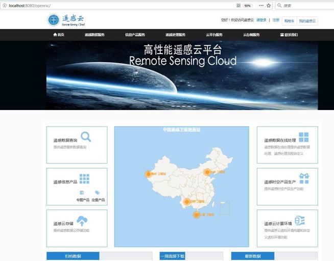
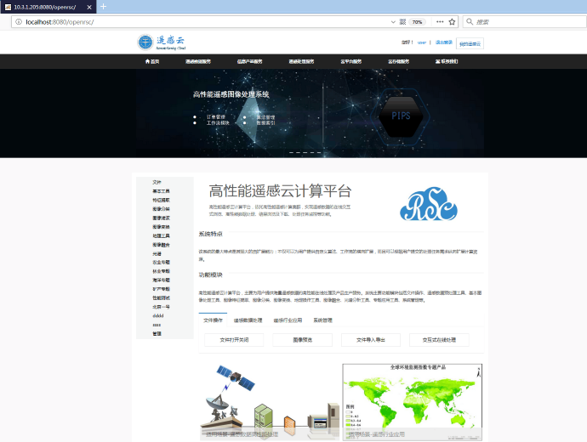
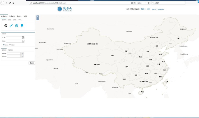
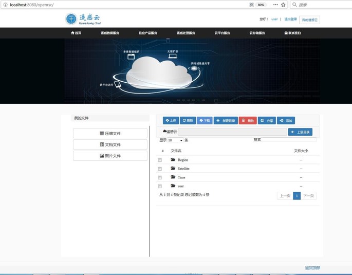
遥感云,基于课题组多年的研究积累及863课题项目经验,开发的基于云计算环境的遥感大数据一体化高性能服务平台,包含多数据中心框架下的自动数据集成、高性能组织与存储、快速检索与访问,高性能数据处理,分布式计算框架下的智能分析与深度挖掘、大区域尺度遥感制图等功能。
获得2025年日内瓦国际发明展金奖,支撑了我国首颗地质行业高光谱遥感卫星“地质一号”的数据处理及产品生产。请访问http://geosat.com.cn/geo-1/免费获取地质一号卫星数据。
团队成员Research Group
团队名称:中国地质大学(武汉)数字地球实验室
团队介绍:主要致力于城市遥感、海岛礁遥感、无人机遥感、复杂地质环境遥感,以及遥感图像智能处理等方面的研究。
微信公众号:数字地球实验室