Yan Jining
Associate professor Supervisor of Master's Candidates
Honors and Titles : 校级最受学生欢迎老师
校级优秀共产党员
本科教学质量评估优秀
华为ICT大赛全国一等奖指导老师
华为ICT大赛全球一等奖指导老师
Gender : Male
Alma Mater : 中国科学院大学
Education Level : Faculty of Higher Institutions
Degree : Doctoral Degree in Engineering
Status : Employed
School/Department : 计算机学院
Discipline : Computer science and technology Spatial information and digital technology Geographic Information Science
Business Address : 未来城校区科一楼508办公室
Email :
2013.9 -- 2017.6
中国科学院大学 信号与信息处理 Faculty of Higher Institutions 博士学位
2010.9 -- 2013.6
中国科学院大学 地图学与地理信息系统 With Certificate of Graduation for Study as Master's Candidates 硕士学位
2006.9 -- 2010.6
新疆大学 电子信息科学与技术 Undergraduate (Bachelor’s degree) 学士学位
2022.12 -- 2023.7
《Journal of Autonomous Intelligence》客座编辑
2023.8 -- 2024.12
《Urban Informatics》客座编辑
2024.1 -- 2025.12
《地球科学》、《Journal of Earth Science》青年编委
2023.8 -- Now
中国太平洋学会海洋大数据与高性能计算分会理事
2021.8 -- 2026.8
中国遥感应用协会定量遥感专业委员会青年委员
2022.4 -- 2022.12
Remote Sensing客座编辑
2022.3 -- 2024.3
Early Career Editorial Board (ECEB) Member(青年编委) of Resources, Environment and Sustainability (RES)
2021.5 -- 2024.5
数字地球学会空间地球大数据专委会 秘书长
2019.6 -- 2020.6
Big Earth Data 期刊编委
2019.7 -- Now
Remote Sensing 期刊编委
长时序遥感数据处理及挖掘
遥感数据组织与管理,长时序遥感数据处理及挖掘,高性能空间数据处理、遥感云计算
高性能空间数据处理
遥感云计算
2017.7 -- 2018.6
计算机学院 网络工程系 宣传委员 副教授 在职
2018.7 -- 2021.4
计算机学院 大数据系 系副主任 副教授 在职
2021.4 -- Now
计算机学院 大数据系 系副主任 副教授 在职
中国地质大学(武汉)数字地球实验室,主要致力于城市遥感、海岛礁遥感、无人机遥感、复杂地质环境遥感,以及遥感图像智能处理等方面的研究。
阎继宁,男,博士,副教授,IEEE Senior Member,高校GIS新锐(2024),国际数字地球学会中国国家委员会委员、空间地球大数据专委会副主任委员,中国图象图形学学会遥感图像专业委员会委员,中国遥感应用协会定量遥感专业委员会青年委员,中国太平洋学会海洋大数据与高性能计算分会理事。主要研究方向包括大规模时序遥感数据管理及智能分析、遥感云计算。近年来主持国家重点研发计划子课题、国家自然科学基金青年项目及面上项目、CCF-蚂蚁科研基金等项目十余项。在RSE、ISPRS P&RS、TGRS、JAG等期刊发表SCI检索论文40余篇(一作/通讯27篇),ESI高被引论文3篇,授权发明专利8项,出版中英文专著3部,第一作者主编教材1部,获得省部级奖项3项,IEEE JSTARS 最佳论文奖1项,美国地质调查局遥感手册(第二版)“遥感云计算”章节主要编写人。担任SCI期刊Remote Sensing客座编辑及Reviewer Board Member,ESCI/EI期刊Big Earth Data、Urban Informatics、Journal of Autonomous Intelligence客座编辑,Resources, Environment and Sustainability (RES)、《地球科学》、《Journal of Earth Science》青年编委。
代表性论文:
[1] Jining Yan, Jingwei Liu, Dong Liang, Yi Wang, Jun Li, Lizhe Wang. Semantic segmentation of land cover in urban areas by fusing multi-source satellite image time series. IEEE Transactions on Geoscience and Remote Sensing, 2023, doi: 10.1109/TGRS.2023.3329709.
[2] Jining Yan, Lizhe Wang, Haixu He, Dong Liang, Weijing Song, Wei Han. Large area land cover changes monitoring with time-series remote sensing images using transferable deep models. IEEE Transactions on Geoscience and Remote Sensing, 2022. DOI: 10.1109/TGRS.2022.3160617.
[3] H. He, J. Yan*, L. Wang, D. Liang, J. Peng and C. Li, "Bayesian Temporal Tensor Factorization-Based Interpolation for Time Series Remote Sensing Data with Large-Area Missing Observations," in IEEE Transactions on Geoscience and Remote Sensing, doi: 10.1109/TGRS.2022.3140436.
[4] Jining Yan, Lizhe Wang, et al. "A time-series classification approach based on change detection for rapid land cover mapping." ISPRS Journal of Photogrammetry and Remote Sensing 158 (2019): 249-262.
[5] Jining Yan, Lizhe Wang, Kim-Kwang Raymond Choo and Wei Jie. A cloud-based remote sensing data production system. Future Generation Computer Systems. 2017. http://dx.doi.org/10.1016/j.future.2017.02.044.
[6] Nan Wu, Jining Yan*, Dong Liang, Zhongchang Sun, Rajiv Ranjan, Jun Li. High-resolution mapping of GDP using multi-scale feature fusion by integrating remote sensing and POI data, International Journal of Applied Earth Observation and Geoinformation, 2024, 129, 103812.
[7] Haixu He, Jining Yan*, Dong Liang, Zhongchang Sun, Jun Li, and Lizhe Wang. Time-series land cover change detection using deep learning-based temporal semantic segmentation. Remote Sensing of Environment 305 (2024): 114101.
代表性专著 & 教材:
[1] Lizhe Wang, Jining Yan, Yan Ma. Cloud Computing in Remote Sensing. 2019.7.10, CRC Press. ISBN: 978-1-138-59456-2.
[2] 阎继宁,陈云亮,王媛妮,宋维静。Python语言应用案例实践教程,科学出版社,2020,ISBN:978-7-03-065284-3.
[3] Lizhe Wang, Jining Yan, Yan Ma, Xiaohui Huang, Jiabao Li, Sheng Wang, Haixu He, Ao Long, Xiaohan Zhang. Cloud Computing in Remote Sensing: A Comprehensive Assessment of State of the Arts. Remote Sensing Handbook, Volume I, 2nd Edition, CRC Press, 2024. eBook ISBN: 9781003541141.
发布的基准数据集及开源代码:
[1] 土地覆盖时序变化遥感监测基准数据集CUG-FFireMCD1,依据全球火灾扰动事件制作的MODIS时序数据集,可以为遥感时间序列变化检测的模型优化和精度验证提供基准。访问链接https://github.com/CUG-BEODL/CUG-FFireMCD
[2] 时序遥感数据语义分割基准数据集,由采自新疆伊犁地区的Sentinel-2高质量光学无云时序遥感影像制作,可以为时序语义分割模型优化和精度验证提供基准。访问链接https://github.com/CUG-BEODL/MTAF-TST.git
[3]时序遥感语义变化检测基准数据集及开源代码。访问链接https://github.com/CUG-BEODL/TSSCD
[4] 1990-2022年中国30m年水土流失空间分布数据集. 访问链接 https://doi.org/10.57760/sciencedb.12876
国际会议:
[1] 2023-9,第三届可持续发展大数据国际论坛(FBAS2023), 北京,分会场共同主席
[2] 2023-8,全球智慧城市峰会暨第三届国际城市信息学大会(GSCS & ICUI 2023), 香港,分会场共同主席
[3] 2023-7, 第13届国际数字地球会议(ISDE2023),雅典,分会场共同主席
[4] 2022-11,第五届地学大数据国际研讨会(BED2022),武汉,分会场召集人
[5] 2020-1, 第四届管理工程、软件工程与服务科学国际会议(ICMSS 2020),武汉,本地主席
代表性工程研发成果:
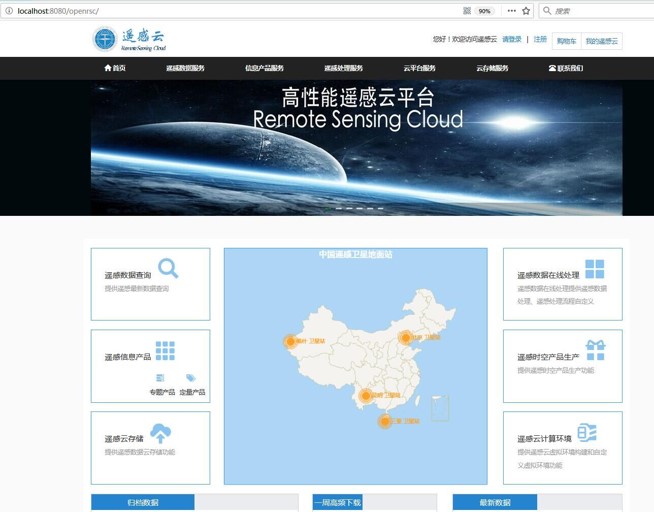
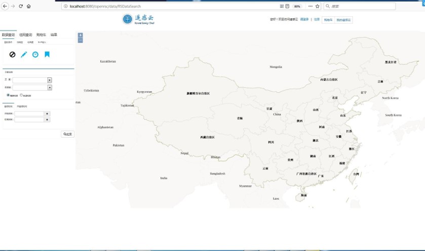
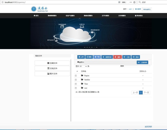
遥感云,基于课题组多年的研究积累及863课题项目经验,开发的基于云计算环境的遥感大数据一体化高性能服务平台,包含多数据中心框架下的自动数据集成、高性能组织与存储、快速检索与访问,高性能数据处理,分布式计算框架下的智能分析与深度挖掘、大区域尺度遥感制图等功能。