
The Last Update Time: ..
科研自述
杨超,博士,副研究员。地理空间智能与三维建模领域研究者,曾主持/参与国家级、省部级科研项目10余项,发表高水平论文30余篇,拥有多项授权专利,出版《智慧城市综合感知》书籍,参与起草制定国家标准,获得地理信息科技进步奖。曾指导本科毕业生获得优秀毕业论文,指导研究生获得全国大学生GIS应用技能大赛二等奖。现任国家地理信息系统工程技术研究中心主任助理兼地球空间感知与计算研究中心主任。
目前致力于地理空间智能与三维重建前沿的研究。参与管理20余人科研团队,直接指导7人的博士生/硕士生精英小组在三维重建前沿领域的深入研究。深耕三维建模技术革新,推动数字孪生、智慧城市等场景落地。
目前与本地企业深入合作,提出基于高斯函数的三维几何高效表示方法,攻克大规模点云实时渲染技术瓶颈。研发复杂场景动态建模系统,高效的提高三维重建的效率与精度。对学生的培养从算法设计到系统部署形成闭环,并有多项项目让学生具体实践。团队涵盖算法开发、工程实现与行业应用全链条,配备高性能计算集群、激光雷达扫描仪等设备,支持三维建模全流程实验。
未来将继续深入三维建模技术革新,融合3DGS与NeRF,提高动态场景建模效率。拓展数字孪生城市、元宇宙内容生成、工业检测等落地场景。为自动驾驶,智慧城市,低空经济等领域提供支撑。
热烈欢迎对三维重建/计算机视觉/深度学习/地理信息科学等相关领域感兴趣的同学报考或交流学习!
研究兴趣(方向)
地理空间传感网、数据挖掘、城市感知、三维重建
具体研究方向
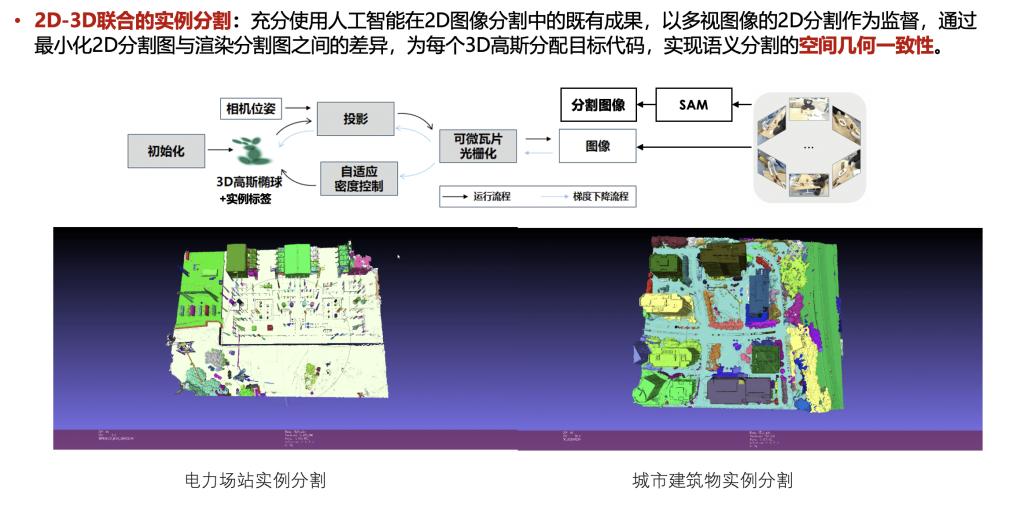
3D场景单体化及实例分割
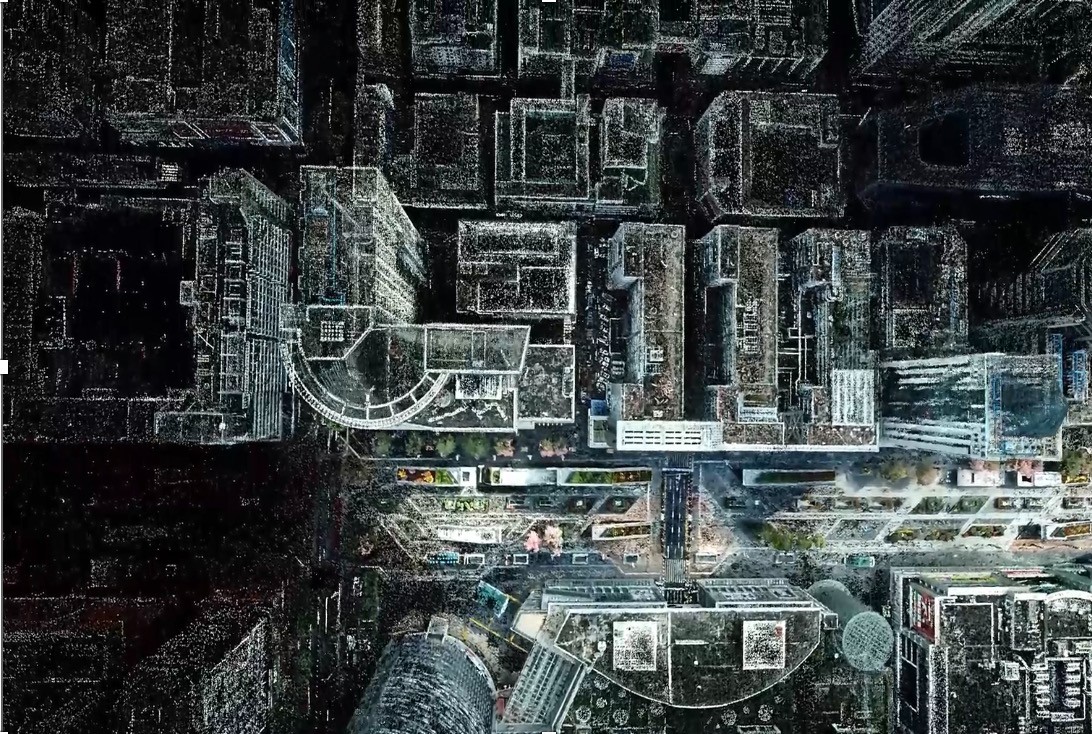
高精度空地一体化数字孪生底座构建

基于3D高斯泼溅的精细场景建模
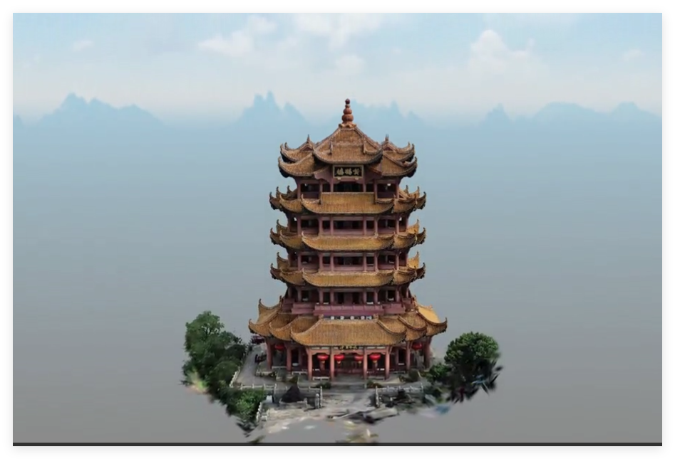
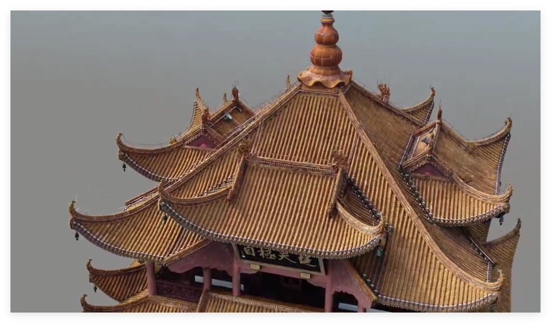
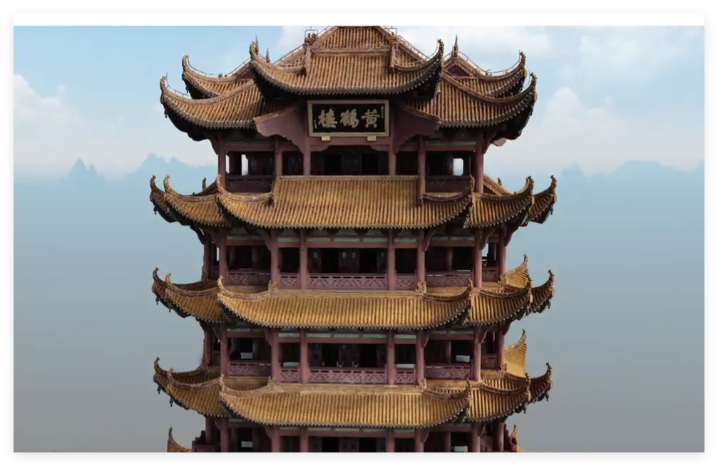
3D高斯的实时可视化与高效渲染

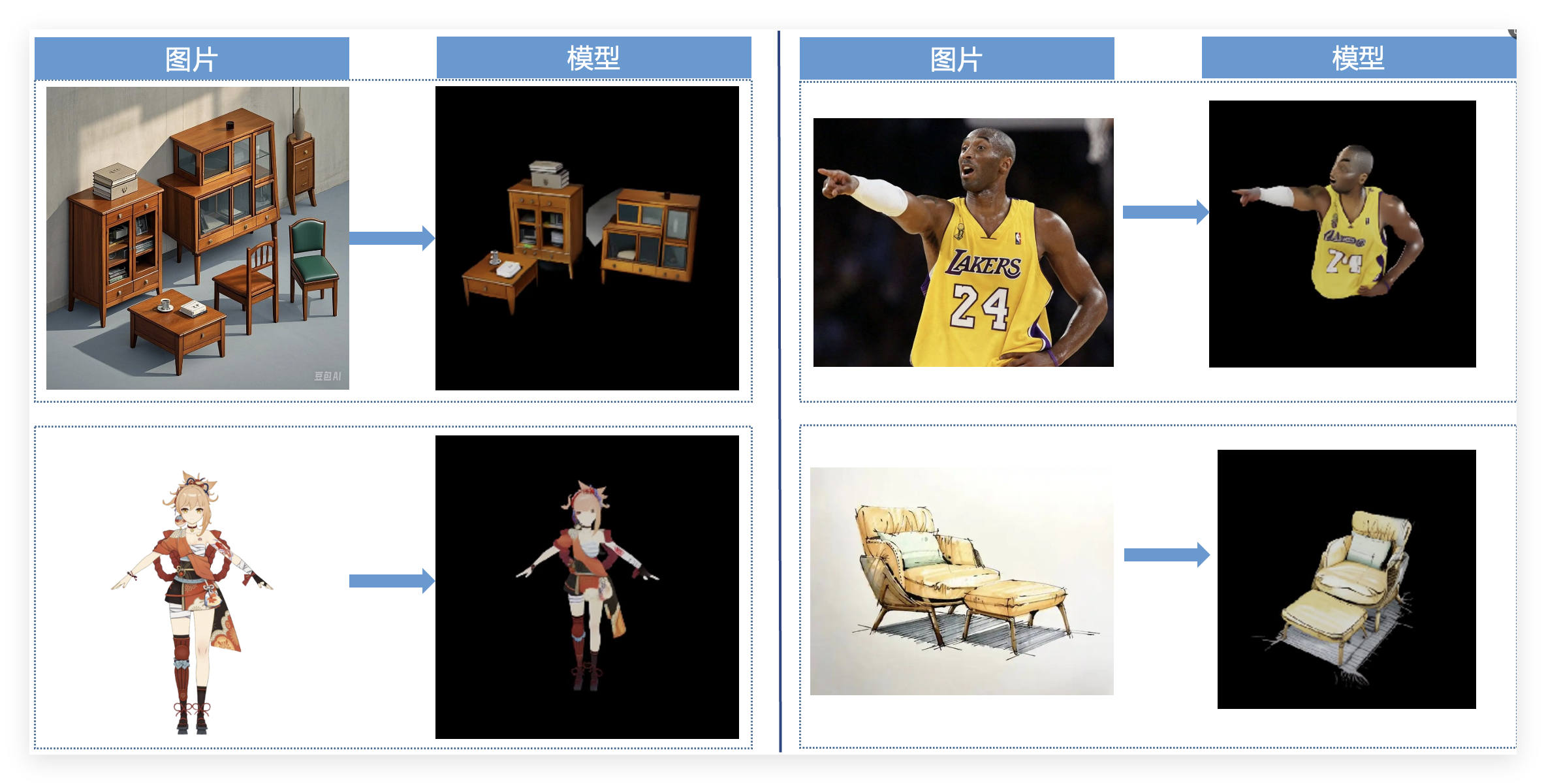
图生3D模型
部分视频:
- https://share.weiyun.com/WWLGudRY
- https://share.weiyun.com/Y4Z3JU29
- https://share.weiyun.com/zUPoKj28
- https://share.weiyun.com/EyuT4Igb
荣誉与奖励
指导学生获得湖北省大学生GIS应用技能大赛二等奖、全国大学生GIS应用技能大赛二等奖
编制标准
城市生命线监测数据分析指南 T/BSTAUM 001—2023
科研成果获奖
低速限定场景智能无人移动感知装备关键技术及应用获得地理信息科技进步奖
主持项目
————纵向项目
1.科技部,国家重点研发计划,城市建成环境遥感智能监测平台与应用示范,2025-2028,70万元,主持
2. 国家自然科学基金委,基于社交媒体数据的城市洪涝事件感知和观测服务方法,2024-2027,46万元,主持
3.科技部,国家重点研发计划,城市运行智能感知与分析决策关键技术, 2020-2023, 60.5万元,主持
4.湖北省科技厅,重点研发计划,测绘遥感大数据高效处理与智能分析 80万元,2020-2024, 主持
5.科技部, 国家重点研发计划, 城市精细场景时空感知设备与在线监测技术, 2019-2022, 105万元, 主持
6.科技部, 国家重点研发计划,位置感知的信息融合协同计算与服务, 2017-2021, 55万元,主持
7.国家自然科学基金委 青年项目 传感网节点环境下地学工作流构建方法方法研究 2015-2018 ,25万元 主持
————横向项目
8.横向一般项目 武穴智慧城市地理信息基础能力平台和数字农业应用平台开发服务 230万元,2024-2025,主持
9.横向一般项目 福贡县草果提质增效草果产业数字一张图 110万元,2023-2024,主持
期刊论文
1. Dong X, Xie J, Tu K, et al. DSFNet: Dual-Stream-Fusion Network for Farmland Parcel Mapping in High-Resolution Satellite Images[C]//2023 11th International Conference on Agro-Geoinformatics (Agro-Geoinformatics). IEEE, 2023: 1-6.
2. Lai C, Chaogui K, Chao Y. Understanding Citizens' emotion States under the Urban Livability Environment through Social Media Data: a Case Study of Wuhan[J]. Journal of Geodesy & Geoinformation Science, 2022, 5(2).
3. Xu L, Chen N, Yang C, et al. A parametric multivariate drought index for drought monitoring and assessment under climate change[J]. Agricultural and Forest Meteorology, 2021, 310: 108657.
4. Qi K, Yang C, Hu C, et al. A multi-level improved circle pooling for scene classification of high-resolution remote sensing imagery[J]. Neurocomputing, 2021, 462: 506-522.
5. Qi K, Yang C, Hu C, et al. Deep Object-Centric Pooling in Convolutional Neural Network for Remote Sensing Scene Classification[J]. IEEE Journal of Selected Topics in Applied Earth Observations and Remote Sensing, 2021, 14: 7857-7868.
6. Shen Y, Shen G, Zhai H, et al. A Gaussian Kernel-Based Spatiotemporal Fusion Model for Agricultural Remote Sensing Monitoring[J]. IEEE Journal of Selected Topics in Applied Earth Observations and Remote Sensing, 2021, 14: 3533-3545.
7. Zhai H, Lv C, Liu W, et al. Understanding Spatio-Temporal Patterns of Land Use/Land Cover Change under Urbanization in Wuhan, China, 2000–2019[J]. Remote Sensing, 2021, 13(16): 3331.
8. Qi K, Yang C, Hu C, et al. Rotation invariance regularization for remote sensing image scene classification with convolutional neural networks[J]. Remote Sensing, 2021, 13(4): 569.
9. Xu L, Chen N, Yang C. Quantifying the uncertainty of precipitation forecasting using probabilistic deep learning[J]. Hydrology and Earth System Sciences Discussions, 2021, 2021: 1-27.
10. Li J, Shen Y, Yang C. An adversarial generative network for crop classification from remote sensing timeseries images[J]. Remote Sensing, 2020, 13(1): 65.
11. He, Z., Deng, M., Cai, J., Xie, Z., Guan, Q., & Yang, C. (2020). Mining spatiotemporal association patterns from complex geographic phenomena. International Journal of Geographical Information Science, 34(6), 1162-1187.
12. Qi K, Yang C, Hu C, et al. Polycentric circle pooling in deep convolutional networks for high-resolution remote sensing image recognition[J]. IEEE Journal of Selected Topics in Applied Earth Observations and Remote Sensing, 2020, 13: 632-641.
13. He Z, Deng M, Cai J, et al. Mining spatiotemporal association patterns from complex geographic phenomena[J]. International Journal of Geographical Information Science, 2020, 34(6): 1162-1187.
14. Bruno S, Yang C, Tian W, et al. Exploring the characteristics of tourism industry by analyzing consumer review contents from social media: a case study of Bamako, Mali[J]. Geo-spatial Information Science, 2019, 22(3): 214-222.
15. Yang C, Xiao M, Ding X, et al. Exploring human mobility patterns using geo-tagged social media data at the group level[J]. Journal of Spatial Science, 2019, 64(2): 221-238.
16. Xu Z, Meng S, Zhong S, et al. Study on temporal and spatial adaptability of crop classification models[C]//2019 8th International Conference on Agro-Geoinformatics (Agro-Geoinformatics). IEEE, 2019: 1-7.
17. Hu, C., Li, J., Lin, X., Chen, N., & Yang, C. (2018). An observation capability semantic-associated approach to the selection of remote sensing satellite sensors: A case study of flood observations in the Jinsha River basin. Sensors, 18(5), 1649.
18. Yang C, Xie Z, Xu Z. An asynchronous Geoprocessing Workflow and its application to an Antarctic ozone monitoring and mapping service[J]. International Journal of Digital Earth, 2016, 9(2): 156-170.
19. 杨超, 杨柳松, 杜阳, 等. 融合图像和时空信息的社交媒体用户活动 分类方法[J]. Geomatics & Information Science of Wuhan University, 2023, 48(3).
20. 王梨名, 祁昆仑, 杨超, 等. 弱监督尺度自适应增强的高分辨率 遥感影像场景分类[J]. Journal of Remote Sensing, 2023, 27(12).
科研著作
出版《智慧城市综合感知》
授权专利
1.徐雨航,盈孟佳,杨超,祁昆仑. (2020). 一种基于众包图像的三维点云场景更新方法. 中华人民共和国国家知识产权局发明专利
2.徐雨航,盈孟佳,杨超,祁昆仑,陈能成.(2021). 基于手机众包成像终端的室内地下应急场景三维建模方法. 中华人民共和国国家知识产权局发明专利
3.杜阳,杨超,祁昆仑.(2021). 基于空间分析的共享单车管理人员服务区分配方法及系统. 中华人民共和国国家知识产权局发明专利
4.王梨名,祁昆仑,杨超,马欣悦. (2021). 基于特征筛选和深度融合的卷积神经网络特征融合算法. 中华人民共和国国家知识产权局发明专利
东华理工学院 地理信息系统 Editor Bachelor's degree
东华理工大学 地图学与地理信息系统 With Certificate of Graduation for Study as Master's Candidates Master's Degree in Engineering
武汉大学 地图学与地理信息系统 Faculty of Higher Institutions Doctoral Degree in Science
中国地质大学(武汉) 从事地理信息系统相关研究。
Telephone:
email:

